In my previous post I talked about an app I use called Rever. I've been looking at alternatives, not because I dislike Rever but because it's an annual cost that in this day and age might be a little too much.
Most mapping apps have an annual subscription, this is fair enough because getting access to maps can be a cost to them, even if they are using OpenMaps, so they have to pass that cost on in some way. I don't have a problem with that but I have to way up whether that cost is appropriate or can I do the same thing for free?
Enter the two most common mapping systems - Google Maps and Apple Maps. Can I do the same thing as Rever with these apps?
In short the answer is yes but it's not that easy to do, and there are significant challenges in doing so. However, for my needs I've worked out a perfect solution and it's most likely a method you've never thought of doing.
Google Maps is crap
Yes, I am an Apple user but my statement isn't anything to do with an Apple vs Google/Android mentality. My statement is that after having used Google Maps and Apple Maps, my conclusion is that Google Maps is crap. Let me explain.
Ever since Google Maps Driving Directions came to New Zealand, I've found them to be out of date and unreliable. When it came I did what anyone would do and I Googled up the route from my work to my house. I could not for the life of me work out why it kept sending me along another route rather than going up the main highway then turn right onto the street where I lived.
I had the view on Satellite and it clearly showed a road joining to the main road. But when I turned off satellite view and showed map view, I found the problem instantly. Google Maps was showing me there was a paper road in that section that joined my house to the main road.
I asked my mate who grew up in the city how long had that section been joined to the main highway and he informed me that it had been at least 10 years before I moved into the city. That meant that Google Maps was using maps that were at least 17 years out of date. ON THE DAY OF RELEASE. Let that sink in.
In fact, there's a couple of sub-developments that we deal with as posties and Google Maps has only just added them in in the past 2 years, despite those sub-developments being in existence for well over 7 years.
If a mapping system can't keep up to date, then how can it be anything other than a crap system? An out of date mapping system is pretty much useless.
Apple Maps works, mostly
I'm not saying Apple Maps is without its issues. No mapping system is perfect because maps change on a council's whim but I will say this, on day one of Apple Maps coming into New Zealand with Driving Directions it did my above test flawlessly while Google Maps was still giving its results. By this time roughly 3 or so years had passed and I had moved out of that house. In fact, Google Maps did not get the proper directions until about 2 years after Apple Maps with driving directions came into NZ. So by that time Google Maps had been using information that was out of date by about 22 years.
Apple Maps has now had routing for about a year or so but there are limitations. However, what I found was those limitations are less that Google Maps which makes Google Maps an even worse application. The biggest limitation is that it only accepts 15 waypoints. Sometimes you need to have more waypoints just to finesse the route a little. However, this is still better than Google Maps which has 9 waypoints and creates the pathetic route you'll see soon.
There is one other limitation which makes Apple Maps' routing less of an option I can use and that is at the moment routing is only available for hiking/walking. I want this ability for motorcycling so routing isn't an option. But there is a way to make it work and it works real well.
An unlikely solution
Working in IT for around 18 years taught me a lot about finding workarounds that a user is comfortable with. I found one for my issue and it involves a very unlikely solution... a spreadsheet.
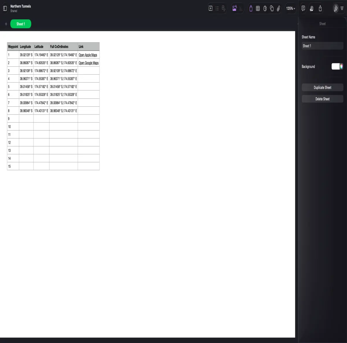
In this above screenshot you'll see roughly how I built this. I setup 15 waypoints, each with a longitude and a latitude. The third field is a concatenation of the two which then gets used to make the links to either Apple Maps or Google Maps.
It's a pretty simple solution and one that works a lot better than it should. I do pretty much run into an issue with Google Maps but it works at the moment with this route because it's less than 9 waypoints. I'm not sure what to do if I have to make a route with the full 15 waypoints because that's going to break Google Maps.
For now though, I'm going to show you the results so you can get a better idea why I feel Google Maps is crap.
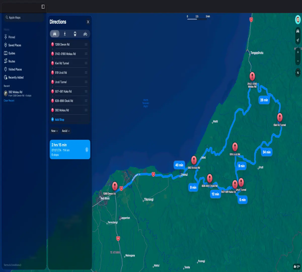
Apple Maps Route
Google Maps
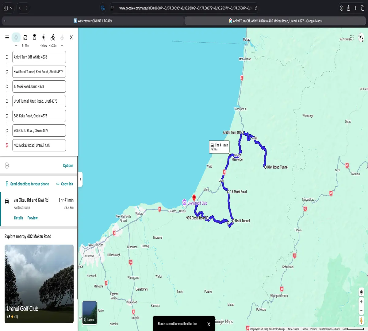
Please forgive the skewed images here, this seems to be a Publish0x thing.
Can you see the issues with Google Maps verses Apple Maps?
See how Apple Maps shows a closed loop but Google Maps shows a straight line? Google Maps is ONLY working on a "Fastest Route" method which has the unfortunate issue of sending us to the furthest point, then sending us back the way we came to go to the next point.
Apple Maps takes us on the most direct route which, for motorcyclists at least, is the most fun route.
The only way to get Google Maps to go the correct route is to add an extra waypoint or two but then we run into the whole "I can only do 9 waypoints" issue.
Not perfect but free
My brief was simply to come up with a routing system that didn't incur any costs. I feel I can safely do that but with some limitations. Rever has around 100 waypoints to be able to make more refined routes. I can get around this using my spreadsheet method (see note below).
While I don't expect much from free options, there are significant issues with Google Maps that means I will refuse with utmost disdain.
This leads me to Apple Maps. I'm not just recommending this app simply because I'm one of the Apple "Sheeple" (the irony is not lost on me that the people who call us that are part of the 98% of people using a platform for no other reason than it's the platform everyone else is using). I'm recommending this app because it is so much better than Google Maps. Your mileage may vary but I've proved with real world searches that Google Maps is woefully inadequate here in New Zealand and that Apple Maps is a much stronger system.
Going with these options also loses me the ability to record my runs. However, I've got this sussed as well with Apple Fitness. I simply chuck it onto Cycle Workout and leave it in my tank bag. It sounds archaic but it actually works as it records my route as well as gives me a sneaky few KJs on my way. As sneaky as it might seem it is kind of legit because it is actually a pretty good workout riding a motorcycle, especially the way I ride.
From this point I can also use an app like Relive to make a little video of my ride before I get around to making a full video from the cameras on the front and rear of my bike.
Like I said above, I find workarounds. I'm super happy about these workarounds because it's more in-depth than the paid version despite the limitations I have. It requires a little more effort but sometimes that makes for a better solution.