Saharan Dust Versus Atlantic Hurricanes
Over the past several years my curiosity around Hurricanes has increased significantly and as we move into August I hope you find this timely too.
Learn about Hurricane's
The US Hurricane season runs from June 1 to end of Nov (on average the season is over by Thanksgiving week). The Atlantic basin & Caribbean are typically calm while the storms ramp up heavily in Aug and September with peak activity being Sept. 10th. Hurricanes are ranked by Wind Scale, this ranking system is known as the Saffir-Simpson Hurricane Wind Scale system - it ranks wind speeds in order from Cat 1-5 with five being the worst. Keep in mind Hurricane's have been having an impact on the Atlantic basin & Caribbean long before the invention of the combustion engine. Don't believe me? Read up on how many Spanish treasure gallon's were lost due to 'Tempest storms'. Some of these highly valuable cargos are still being sought out by modern treasure hunters.
External Factors impacting Life cycle of a hurricane
I hate to point of the obvious but the seasons as well as weather patterns directly impact hurricane development and seasons. However, I brought you here to delve into what I found earlier this year. Saharan dust! Each year, over one hundred million tons of Saharan dust gets blown across the Atlantic, some of it reaching as far as the Amazon River Basin.
Saharan dust can affect hurricane activity in several ways:
- Dust acts as a shield which keeps sunlight from reaching the surface. Thus, large amounts of dust can keep the sea surface temperatures up to 1°C cooler than average in the hurricane Main Development Region (MDR) from the coast of Africa to the Caribbean, providing hurricanes with less energy to form and grow.
- The Saharan Air Layer (SAL) is a layer of dry, dusty Saharan air that rides up over the low-level moist air over the tropical Atlantic. At the boundary between the SAL and low-level moist air where the trade winds blow is the trade wind inversion--a region of the atmosphere where the temperature increases with height. Since atmospheric temperature normally decreases with height, this "inversion" acts to but the brakes on any thunderstorms that try to punch through it. This happens because the air in a thunderstorm's updraft suddenly encounters a region where the updraft air is cooler and less buoyant than the surrounding air, and thus will not be able to keep moving upward. The dust in the SAL absorbs solar radiation, which heats the air in the trade wind inversion. This makes the inversion stronger, which inhibits the thunderstorms that power a hurricane.
- Dust may also act to produce more clouds, but this effect needs much more study. If the dust particles are of the right size to serve as "condensation nuclei"--centers around which raindrops can form and grow--the dust can act to make more clouds. Thus, dust could potentially aid in the formation and intensification of hurricanes. However, if the dust acts to make more low-level clouds over the tropical Atlantic, this will reduce the amount of sunlight reaching the ocean, cooling the sea surface temperatures and discouraging hurricane formation.
As August moves in,
The important change to point out is the dry air, dust and disruptive breezes, called wind shear, tend to diminish, while at the same time, the oceans are approaching maximum warmth. However, dry air, dust and wind shear will be factors against short- to medium-range tropical development of a robust tropical wave that pushed westward and just off the coast of Africa.
Very warm water, low wind shear and moisture help storm development, while current steering breezes would guide the system near the northern islands of the Caribbean from the Leeward islands to some of the Greater Antilles in early August.
One should also consider the Madden-Julian Oscillation (MJO). A lesser-known phenomenon, is expected boost the anticipated Atlantic uptick in August.
Combined with a decrease in wind shear, Sahara Desert dust and dry air drop off, there may be a frenzy of tropical systems at times from August to September and October. And the rise in the number and intensity of Hurricanes rises in that same time frame Aug/Sept/Oct. Coincidence?
Major Storm Season
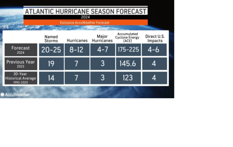
Colorado State University (CSU) along with AccuWeather meteorologists have been warning of a super-charged Atlantic hurricane season for 2024. And this season started off with the earliest recorded CAT 5 storm ever. This storm was Beryl and hit Texas and caused widespread damage including power outages that lasted 2-weeks in some areas and brought heavy rain all the way up into the Great Lakes Region of the USA.
Wondering aloud
Since, animal habitats change over time through natural processes is it safe to assume the weather can change too?
Summary
Seems like a major weather cycle/pattern the media fails to bring to everyone's attention. Is this done intentionally? Nah, for certain they wouldn't do that, would they? Or perhaps they are just trying to repeat the same narrative over and over until you buy off on their solution. I trust you learned something today and appreciate you making it all the way till the end.